Two months of travel from Portugal to Suriname has gone by in a wink. After stops in the Canaries, Cap Verdes and French Guyana my crew was bound to depart for Mexico. We had an amazing time together but still I was looking very much forward to that next leg, which would be my first solo sail with Fitz Roy.
The goal was to reach Grenada by the 11thof March when friends from back home would fly in to spend some time with me on the boat. The passage from Suriname along the north coast of South America is an easy one but it must be planned well. Being late in the season had the advantage of stable winds with few squalls and a well established north equatorial current. But the start would have to be timed well, leaving the Suriname river with the tide and getting away from the coast in daylight was key.
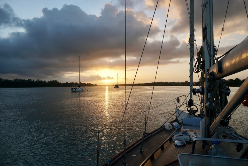
Early morning start, sunrise over the Suriname River
Do your research
What first bugged me was the amount of fishing vessels and possible piracy along the coast. Some research showed pretty quickly that piracy was limited to crimes amongst fishermen over disputed territory and attacks on oil platforms off the coast of Trinidad. Another concern were the huge new developments of oil fields off the coast of Suriname and Guyana. All of them uncharted, so that I had to use alternative methods of defining where they are, by using and combining both live and historical AIS data, called density charts. (AIS is an Automatic Identification System that is mandatory for big ships, more and more sailing yachts also Fitz Roy have such a transponder that exchanges voyage data with other ships and prevents collision at sea.) Fishing traffic when filtered by ship type on Marinetraffic showed me where the big fishing boats were going and working. That of course did not include the small inshore fishing boats. The NW setting currents are known to be strongest offshore which would be my favorite place to be anyway.
Considering weather
All mayor weather models including ECMWF, GFS, Predictwind and ARPEG were agreeing on a very steady 15-20 knots from the NE. I used rain and CAPE index (Convective Available Potential Energy) to predict thunderstorm activity, which turned out to be inexistent during my window of passage, making chances of severe weather very unlikely. Another difficult thing to predict are ocean currents. The Mercator, RTOFS and Hycom models all showed some different strengths but more or less agreed on the location of the current some 80 nautical miles offshore. I also downloaded synoptic charts by NOAA that could be overlaid together with the GRIB and current data in OpenCPN, giving a very good picture of pressure distribution and location of tropical waves.
Considering traffic
Traffic was a big issue for this leg. A major ocean shipping lane runs along the north coast from Brazil to the north tip of Trinidad and on to Panama. The inshore zone features many local fishing boats without AIS and lots of traffic from and to the oil fields. Big boy traffic lane and inshore area are well separated by the huge Liza oil production field some 50 nautical miles off Guyana, which started its production in January 2020 and was not yet charted. So a decision had to be made between going either north of Liza, joining the big guys or staying south, wrangling with the small fishing fleets. Having made very good experience with big shipping traffic and their curtesy towards sailing yachts I quickly decided to go north around Liza and sail with the big ships. Due to piracy some yachts sailing this stretch turn off their AIS broadcast and were even running without lights in the past. From the very beginning I was clear that I will be running with both lights and AIS on, as collision would be much more likely than getting kidnaped by a lousy equipped pirate vessel that would have no way of receiving my AIS transmission.
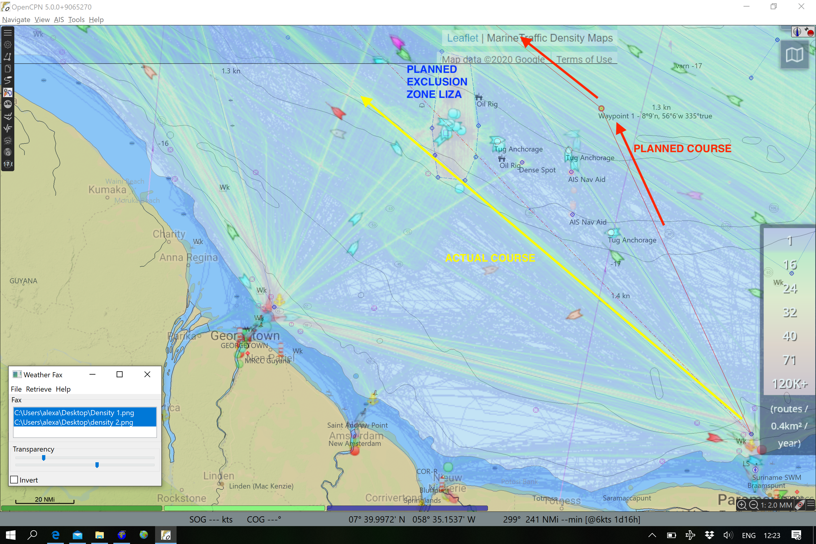
Open CPN screenshot with Marinetraffic AIS density overlay. Red is the planned route, yellow the actual, well separated by many oil platforms. The biggest one being LIZA (uncharted) wich I marked as exclusion zone based on AIS historic and live data.
Write up a roadbook
I filtered tugboats on Marinetraffic.com and set the map to density, giving me a nice picture as to where the traffic of the oil production goes. This screenshot was georeferenced and overlaid in Open CPN. I then marked some exclusion zones, where I was expecting the Liza oilfield (you can find the approximate location marker on NFL). Also from the density charts I marked the major ocean shipping lanes since fishing boats avoid these areas in order not to loose their expensive gear. Filtering all fishing vessels, I marked some areas where big fishing boats where hanging out on the digital chart. Around all that information and taking into account the wind angles, I plotted my course and marked two waypoints that I would need to get me to the north tip of Tobago where I would turn west towards Grenada.
Filing a float-plan
A float-plan is a piece of information, that states your intentions and what to do if you go missing. It mostly stays with your friends or family who would be contacted by the authorities in case you set off your EPIRB (Emergency Position Indicating Radio Beacon). For this trip I was in touch with Glenn at Boatwatch.org. He offers to take float-plans and run check-ins daily and notify authorities, if you go missing. Glenn is very serious about this and has clear protocols. I needed three alternative means to contact him in order to make sure he does not alert anyone just because I am unable to contact him due to minor technical reasons. Our first contact was to be through the SSB radio net known as the SCCA net on 8104khz each morning, where he is the net-controller. If that fails I send him an email awaiting his “received” message. If that does not come, I call him with my sat phone until 22:00 UTC the latest. If he does not hear from me he will assume that I’m missing and inform authorities. If I miss another check-in (a day later) they will start search and rescue efforts. It worked very well and gave some peace of mind. I knew Glenn, who is a former FBI agent with ties to the USCG, would be the man to find me. Check out Boatwatch.org and my float-plan at svfitzroy.com/sar for an example.

Glenn at work at his desk in Florida. Check out Boatwatch.org to file a float-plan yourself
That night all prep was completed and I packed away my dinghy which is stored below deck on longer passages. I watched the sunset over the jungle river and had a cold beer, thinking of all the great times we had in Suriname. Unlike previous years, this year I was not nervous about upcoming trips like the Atlantic crossing or my first solo sail tomorrow. I had a good night’s sleep.
Go have a nice trip!
I left Domburg at 6 am, riding the tide down the Suriname river. Exiting the river bar was rougher than I expected. Sailing hard on the wind, with the outgoing tide and the incoming Atlantic swell throwing up some steep chop. Depths of no more than 20 meters extend far out into the Atlantic and there was no quick transition into deeper water and calmer waves anytime soon. The wind had a slightly more northerly component and I soon realized that I would have to be sailing closehauled for a good 12 hours to get to my waypoint in order to get around Liza on the north side. I quickly made the decision to alter course to 310° heading for the southern tip of the Liza oil production field. I knew I would have to stay up all night to watch for fishing boats, but I wouldn’t be getting any good rest bashing into the waves anyway.
I was tired from getting up early. With many fishing boats only displaying a strobe light I had to concentrate to make out their intentions and the nights in the tropics are long as the sun goes down very quickly.
Around midnight I saw the first glow of the oil fields in the distance and a few hours later a big torch burring up oil came into view and subsequently the first AIS targets of about 50 tugboats all waiting around the panama registered drill ship called the Liza Destiny. It was a hustle and bustle and much chatter on the VHF. Exxon did some exploration here in Guyana in the last years and had a major strike with Liza, wich is now one of the biggest oil projects in the americas.
As the sun came up I passed some seamounts rising up to 140 meters just south of Liza (a good reference if you are planning to sail this route). One hour later I went back onto my original course directly heading for Tobago. Finally I was in deep water of about 2000 meters, no more fishing traffic, a perfect wind angle, nice round swell and a gorgeous day of sailing waited for me.

Screenshot of Open CPN whilst underway. The location of the uncharted oil field is given a away by the AIS targets close-by. FITZ ROY (red) going around LIZA in the south. Very accurate forecast of LIZA’s position thanks to AIS density charts.
All of a sudden I was not feeling tired anymore, I cooked up some food and enjoyed the glorious sailing. The full sails were up and we logged a sustained boat sped of 7.5 knots so with the added current Fitz Roy was racing along at 8.5+ knots over ground. Brilliant!
Night came and I chatted with a tanker that was slowly catching up to me from behind. He agreed to keep a watch with his radar for me while he is in range. I woke up two hours later by his call on the radio. He passed my while I was sleeping at a safe distance and was now 10 miles ahead, we wished us well and off he went. I did some 30 minute naps and shortly after the sun came back up.

Sailing around the northern tip of Tobago at sunset
Another glorious day awaited. I called in to the SSCA HF radio net on my SSB radio at frequency 8104. The connection was much better today than yesterday and I could give Glenn the “roger-roger” meaning that all is well on board. I did some unsuccessful fishing and cooked up some risotto. As the sun got lower, I could see Tobago in the distance. The north coast of Tobago has some strong currents and can kick up some nasty swell so I passed it about 3nm to the north right at sunset. And boy it was a beautiful one. I played some tunes and felt sorry for not stopping in Tobago. It quickly went dark and I discovered a big glow on the horizon. The AIS showed a tanker marked as “not under command”. Most likely a bunkering station selling cheap Venezuelan fuel to ships passing by.
Later in the night I had some fishing traffic and three Dutch sailboats traveling in a convoy from Tobago to Grenada. I had full sails up going wing on wing, passing all of them like a sports-car on the German Autobahn. Lazy buggers! The guys called me on the radio in the morning and of course I was a bit proud to tell them that I’m a solo sailor coming from Suriname.

Entering Port Louis Marina, St. Georges, Grenada
I decided to go into St Georges as the smaller marinas on the south side might be closed due to the global outbreak of COVID-19.
As I came around the southern tip of Grenada the wind increased, the sun came up and I felt a sudden rush of energy. I rounded Point Salines and tacked all the way up to St Georges. Ken on Silverheels 3 anchored on the other side of the Island was apparently contacted by Glenn to report my arrival and must have seen me on the AIS. He gave me a shout on the VHF and a warm welcome to Grenada!
A glance on my watch, a look into the log, some basic math and I realize that we did 8.24 knots average speed (over ground) during the last three days. On a 36ft sailboat of 7.5 tons, German Frers you’re a star!